The tide does not rise at a steady rate. It starts slowly after low water, speeds up through the middle of the rise, and slows again as it approaches high water — a shape close to a sine curve. The rule of twelfths turns that curve into six numbers you can hold in your head. Because it is an approximation of a shape, it works exactly as well as the real tide resembles the shape, which is the first thing to understand about it.
The rule
Divide the range of the tide — the difference between the high-water and low-water heights — into twelve parts. Over the roughly six hours from low water to high water, the tide rises by approximately:
| Hour after LW | Rise during that hour | Total rise so far |
|---|---|---|
| 1st | 1/12 of range | 1/12 |
| 2nd | 2/12 | 3/12 (a quarter) |
| 3rd | 3/12 | 6/12 (half) |
| 4th | 3/12 | 9/12 (three quarters) |
| 5th | 2/12 | 11/12 |
| 6th | 1/12 | 12/12 (all of it) |
Graph of height of tide against time with the rule-of-twelfths blocks overlaid on a smooth curve.
The same sequence, 1-2-3-3-2-1, describes the fall from high water to low water. The two useful checkpoints are that half the range has come in three hours after low water, and that the middle two hours carry half the range between them — the height changes fastest around mid-tide.
Try it: rule of twelfths, hour by hour
Interactive: a slider moves through six tidal hours showing the height from the rule of twelfths against a symmetrical tidal curve.
A worked example
Low water is at 06:00 with a height of 1.0 m; high water is at 12:00 with a height of 5.0 m. The range is 4.0 m, so one twelfth is 0.33 m.
| Time | Twelfths risen | Rise | Height of tide |
|---|---|---|---|
| 06:00 (LW) | 0 | 0.0 m | 1.0 m |
| 07:00 | 1 | 0.3 m | 1.3 m |
| 08:00 | 3 | 1.0 m | 2.0 m |
| 09:00 | 6 | 2.0 m | 3.0 m |
| 10:00 | 9 | 3.0 m | 4.0 m |
| 11:00 | 11 | 3.7 m | 4.7 m |
| 12:00 (HW) | 12 | 4.0 m | 5.0 m |
Applying it: crossing a bar that dries
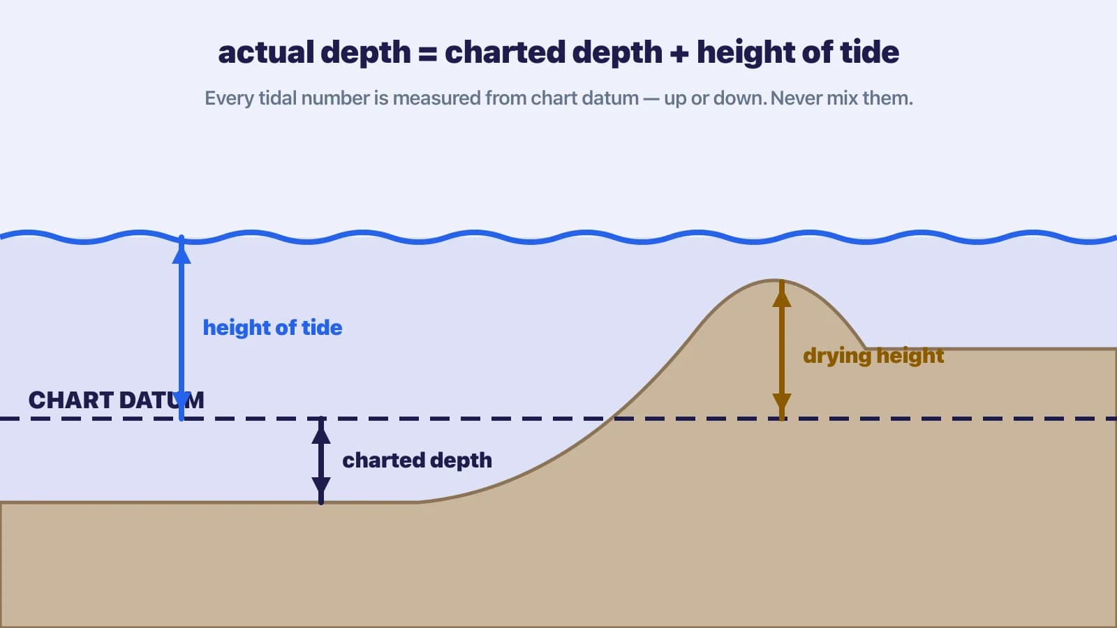
Keep the quantities separate and the arithmetic looks after itself. A drying height is measured upward from chart datum to the top of a feature that uncovers at low water; a height of tide is measured upward from chart datum to the sea surface. So the depth of water over a drying feature is height of tide minus drying height. Suppose the bar dries 1.5 m, your draught is 1.5 m and you want 1.0 m under the keel: you need 1.5 + 1.0 = 2.5 m of water over the bar, so a height of tide of 2.5 + 1.5 = 4.0 m. On this tide that is about 10:00.
Applying it: anchoring over a charted depth
A charted depth (sounding) is measured downward from chart datum to the seabed, so the actual depth is charted depth plus height of tide. At 09:00, with a height of tide of 3.0 m, a spot charted at 2.0 m has 5.0 m of water. With a 1.8 m draught that is 3.2 m under the keel now. At the next low water, with a height of tide of 1.0 m, there will be 3.0 m of water — 1.2 m under the keel, which may be enough, but check the swinging circle for shallower soundings and any drying patch nearby.
Cross-section showing chart datum, charted depth, height of tide, drying height, draught and under-keel clearance.
What the rule assumes
- The tide takes about six hours to rise and six to fall. If the actual interval is 5 h 30 or 6 h 45, scale the hours proportionally, or accept some error.
- The curve is symmetrical about mid-tide. Many ports are close to this; some are nothing like it.
- You are using predicted heights. Weather can add or remove several tenths of a metre: high pressure and offshore winds lower the tide, low pressure and onshore winds raise it.
- You have the range right. Springs and neaps change the range, and the rule is only as good as the heights you feed it.
Heights are not streams
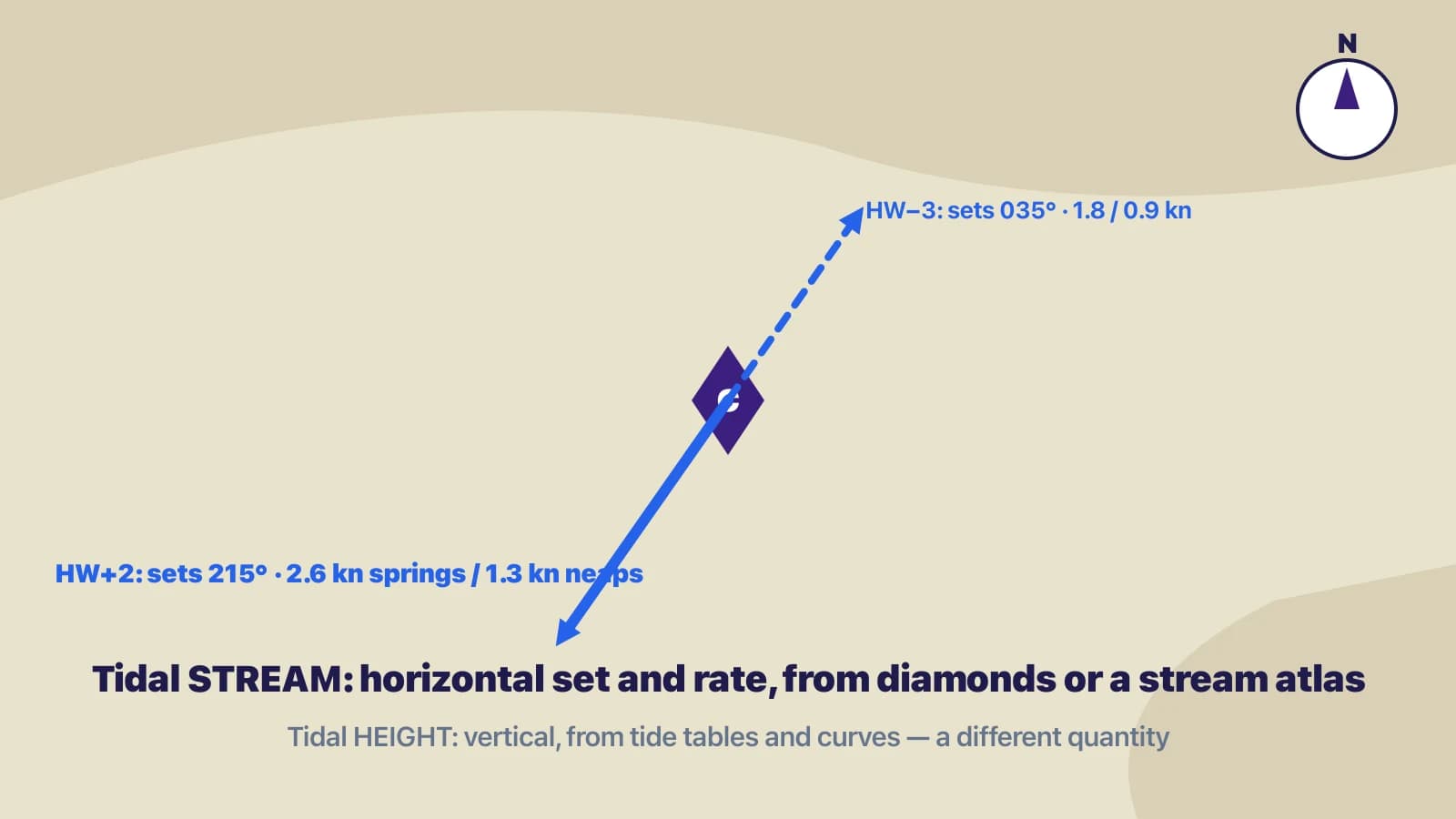
A common extension of the rule is “so the current is strongest at half tide”. That is a different quantity and it is not generally true. The height of tide is a vertical measure. The tidal stream is a horizontal flow with its own rate and direction, and the times of slack water and of maximum rate depend on the geography of the place. In some open-coast locations the stream does turn around high and low water and run hardest in between; in many estuaries, straits and bays the timing is shifted by an hour or more, and off some headlands the stream runs hardest close to high water. There is no universal relationship between high water, low water, slack water and maximum stream — which is why the rule of twelfths says nothing about it.
Two graphs: height of tide over twelve hours, and tidal stream rate over the same period with slack water not coinciding with high and low water.
For streams, use the official data: tidal diamonds on the chart with their table of set and rate referenced to HW at a standard port, a tidal stream atlas, or, in U.S. waters, NOAA's tidal current predictions, which are published separately from tide height predictions for exactly this reason.
When to use the tidal curve instead
Use the port's tidal curve from the almanac or tide tables whenever you are at the chart table, whenever the margin is tight, and in exams. The curve handles asymmetric tides, the spring/neap interpolation, and secondary port corrections, none of which the rule attempts. The Solent and the ports of the eastern English Channel, with their double high waters and long stands, are the standard examples of places where the rule of twelfths can put you aground; so are any ports whose printed curve looks obviously lopsided.
Check yourselfHW is 4.6 m at 14:00 and the next LW is 0.6 m at 20:10. Using the rule of twelfths, roughly what is the height of tide at 16:00?Show answer
Range = 4.0 m, so one twelfth ≈ 0.33 m. Two hours after HW the tide has fallen 1/12 + 2/12 = 3/12 of the range = 1.0 m. Height of tide ≈ 4.6 − 1.0 = 3.6 m. The fall actually takes 6 h 10 min, slightly longer than six hours, so the true figure will be a little higher than 3.6 m — a reminder that this is a check, not a calculation to bet the keel on.
Key takeaways
- 1-2-3-3-2-1 twelfths of the range, hour by hour, from LW to HW or HW to LW. It is an approximation of a symmetrical six-hour curve.
- Measure everything from chart datum: actual depth = charted depth + height of tide; water over a drying feature = height of tide − drying height; clearance = depth − draught.
- The rule says nothing about tidal streams. Slack and maximum stream are not tied to HW, LW or half tide in general — look them up.
- Use the tidal curve at the chart table, in exams, and anywhere the curve is asymmetric or the margin is small.